

The trough of Tropical Storm Nuri (international name) and the prevailing northeast monsoon are expected to bring rains over large parts of the country, according to the Philippine Atmospheric, Geophysical, and Astronomical Services Administration (PAGASA) on Wednesday.
Although Nuri is not expected to enter the Philippine Area of Responsibility (PAR) or cause any direct effect, PAGASA said its extension may affect the eastern part of Mindanao, according to its 5:00 am advisory.
“Yung trough or extension ng kaulapan nitong bagyo ay inaasahan natin na magdadala ng kaulapan at magdudulot ng pag-ulan sa eastern section ng Mindanao [The trough or extension of the storm’s cloud band is expected to bring cloudiness and rainfall over the eastern section of Mindanao],” PAGASA weather specialist Chenel Dominguez said.
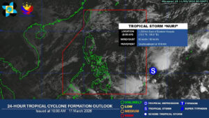
In a separate 10:00 am tropical cyclone monitoring update, PAGASA said Tropical Storm Nuri was last located 1,220 kilometers east of Eastern Visayas.
It is packing maximum sustained winds of 65 kilometers per hour (kph) and gustiness of up to 80 kph, moving southeastward at 10 kph.
In the next 24 hours, the trough of Nuri is expected to bring cloudy skies with scattered rains and thunderstorms over Dinagat Islands, Surigao del Norte, Surigao del Sur, and Davao Oriental.
PAGASA warned of the possibility of flash floods or landslides due to moderate to at times heavy rains.
Meanwhile, the northeast monsoon, locally called amihan, is likely to affect Luzon and the Visayas, but no significant impacts are expected.
Batanes, Cagayan, Isabela, and Aurora may experience cloudy skies with light rains in the next 24 hours.
Metro Manila, the rest of Luzon, and the Visayas may see partly cloudy to cloudy skies with isolated rains.
Seperately, the rest of Mindanao may experience partly cloudy to cloudy skies with isolated rain showers or thunderstorms due to localized thunderstorms.
PAGASA warned of possible flash floods or landslides during severe thunderstorms. — Edg Adrian A. Eva