


Key takeaways
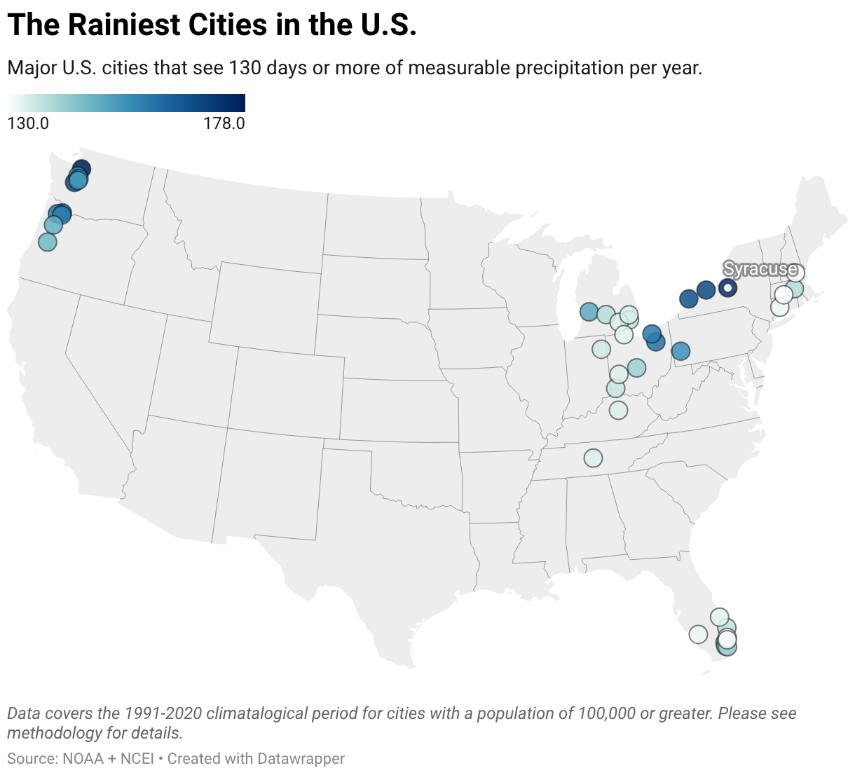
- Everett, Syracuse, and Tacoma are the rainiest major cities in the U.S., seeing measurable rainfall for around half of the days in a year.
- The wettest cities are largely located around the Great Lakes and in the Pacific Northwest, where frequent, light rain is common.
- As the climate warms, rainfall is becoming heavier and less predictable worldwide, leading to greater risks of extreme events like flooding and drought.
Rain can be magical. It can fall as gently as a mist or hard as hail, produce nostalgic smells unique to a specific city or place, and even shape regional identity. It can also bring many benefits, including cleaner air and lusher ecosystems.
While sunnier cities have been popular migration destinations since the pandemic, rainier, cloudier cities are often more affordable and today are home to some of the hottest housing markets in the nation.
However, too much rain can be devastating and lead to floods, landslides, avalanches, and more, which are becoming more common as the planet warms. That’s why it’s important to understand an area’s climate before moving or buying a home there.
So, if you’re considering moving to a new area but aren’t sure what their climate is like, we’re here to help. Whether you like the sun and are looking for places to avoid, or love the rain and just want more, Redfin has compiled a list of the rainiest cities in the U.S. to help you move with confidence. Read on to learn more and discover if one of these cities is right for you.
What are the rainiest cities in the U.S.?
Everet, Syracuse, and Tacoma are the rainiest cities in the U.S., seeing measurable precipitation nearly every other day. Rainfall is seasonal in these cities, with more falling in the fall, winter, and spring, and less in the summer.
In general, all of the “rainiest” cities are characterized by frequent gloom rather than heavy rain.
| City | Average # of rainy days per year | Average annual precipitation | Record annual precipitation (year recorded) |
| Everett, WA | 178 days | 33.4” | 50.2” (1954) |
| Syracuse, NY | 174 days | 39.9” | 58.2” (1976) |
| Tacoma, WA | 168 days | 42.0” | 51.6” (2017) |
| Rochester, NY | 168 days | 35.1” | 45.4” (2017) |
| Buffalo, NY | 166 days | 40.7” | 53.6” (1977) |
| Vancouver, WA | 163 days | 42.3” | 65.8” (1996) |
| Akron, OH | 160 days | 41.6” | 65.7” (1990) |
| Hillsboro, OR | 159 days | 35.9” | 62.6” (1996) |
| Cleveland, OH | 158 days | 41.0” | 65.3” (2011) |
| Portland, OR | 157 days | 36.9” | 63.2” (1996) |
If we dropped the population threshold to 20,000, Hilo, HI would easily be the rainiest city by both annual rainy days and total rainfall. It sees rain about 273 days per year, totaling roughly 120”. But the rain is often intermittent, leaving plenty of dry stretching throughout the day.
Why are these cities so rainy?
The rainiest cities in the U.S. are clustered in two distinct parts of the country: the Pacific Northwest, and the Great Lakes.
The Pacific Northwest is famously wet and dreary, and for good reason. Most of the region’s rain originates over the Pacific Ocean, where winds carry moist air and low-pressure systems toward the coast. These weather systems commonly bring cool, mild conditions and frequent light rain during the wet season, which generally runs from October through March or April. Rainfall is especially heavy on the west-facing slopes of the Olympic and Cascade Mountains, helping make parts of coastal Washington and Oregon among the wettest places in the continental U.S.
On the other side of the country, the Great Lakes are the biggest influence. Cold air moving in from the west or northwest passes over the relatively warmer lakes, picking up heat and moisture that can produce rain, snow, and persistent cloud cover downwind. This phenomenon is known as “lake-effect” precipitation. Cities east and southeast of the lakes, including Buffalo, Rochester, and Syracuse, experience this pattern frequently.
It might be surprising to learn that famously wet cities like Seattle aren’t among America’s rainiest cities, seeing fewer rainy days than places in Western New York and far less total precipitation than cities in the South. This is largely because Seattle is often sits in a rain shadow behind the Olympic Mountains, causing it to receive fewer rainy days than cities in the “convergence zones” to the north and south (e.g. Everett and Tacoma).
The rainiest cities based on annual precipitation total
Many U.S. cities see sun for the majority of the year, but also receive strong storms that can produce dozens of inches of rain at a time. While these cities aren’t very gloomy, they can be extremely wet, which is an important factor to consider if you’re planning on moving.
Here are the rainiest major U.S. cities based on average total annual rainfall.
| City | Average annual precipitation | Average # of rainy days per year | Record annual precipitation (year recorded) |
| Hialeah, FL | 72.9” | 141 days | 93.2” (1999) |
| Miami, FL | 67.4” | 141 days | 89.3” (1959) |
| Mobile, AL | 67.1” | 117 days | 86.6” (1975) |
| Metairie, LA | 63.4” | 115 days | 102.4” (1991) |
| Lafayette, LA | 62.8” | 118 days | 85.0” (1905) |
| Beaumont, TX | 62.1” | 110 days | 104.3” (2017) |
| Pembroke Pines, FL | 62.0” | 148 days | 88.6” (2023) |
| Baton Rouge, LA | 61.9” | 114 days | 90.6” (2016) |
| West Palm Beach, FL | 61.8” | 137 days | 108.7” (1947) |
| Fort Lauderdale, FL | 61.0” | 131 days | 113.9” (2023) |
All of these cities are in the Southern U.S. where strong storms produce most of their rain. Rain more commonly comes in the summer and fall, primarily from tropical storms, hurricanes, thunderstorms, and other systems – but it rains year-round. Additionally, every one of the above cities have very high flood and wind risks due to the frequency and severity of rainfall.
What is the rainiest place in the U.S.?
The outright rainiest place in the U.S. is most likely a section of the Hana Forest Reserve in East Maui called the Big Bog. It sees about 31.6 feet (379”) of rain per year, with at least some rain falling nearly every day.
However, the place that is more commonly cited as the rainiest place on Earth is the peak of Mount Wai’ale’ale on the island of Kauai in Hawaii. The 5,100-foot tall mountain gets about 29.8 feet (358”) of rain per year (although exact numbers vary by source). Neighboring Mount Kawaikini sees a nearly identical amount. Some sources report upwards of 450” of rain per year for Wai’ale’ale, and an annual record of either 666” or 683” in 1982.
The rainiest inhabited place in the U.S. is Glenwood, HI, southwest of Hilo. The tropical neighborhood sees an average of 229” of rain across 301 rainy days per year.
These places get so much rain because of orographic lifting, which happens when air rises, cools, and condenses into precipitation. In Hawaii’s case, moist trade winds from the Pacific are forced up the islands’ steep mountains, causing the air to cool, condense, and produce nearly constant rainfall on windward (northern/eastern) slopes.
Why rainfall matters when choosing where to live
Precipitation is an increasingly important factor for relocating homebuyers – especially those moving to or from areas prone to flooding. Insurance is one reason why: As heavy rain and flooding becomes more common, homeowners and flood insurance can become harder to find and more expensive to purchase.
If you’re considering moving to a flood-prone part of the country, insurance costs and availability will likely factor into your decision. You can also prepare your home for heavy rain and flooding by keeping gutters and storm drains clear, sealing vulnerable areas, improving drainage around your property, and moving valuables and important documents above potential flood levels.
If your home does flood, what you do afterwards matters, too. Prioritize safety, assess water quality, document damage, and contact your insurance company.
Before you move, try using Redfin to understand a home’s climate risks. Click on any property to see its susceptibility to extreme heat, flooding, fire, and more, as well as average monthly temperatures, precipitation, and typical daily sunshine. Redfin partners with the Weather Company, Shadowmap, and First Street (now owned by MSCI) to display this data for nearly every property in the U.S.
How is precipitation changing?
Due to climate change, most of the world is receiving more precipitation in stronger, less predictable storms. Since 1901, global precipitation has increased by 0.08 inches per decade, while in the lower 48 U.S. states, it has increased by 0.17 inches per decade.
This is altering rainfall patterns in traditionally wet places, causing longer dry seasons and shorter but more intense wet seasons. In places like Seattle, for example, rain is more commonly falling in downpours rather than the dayslong drizzle it’s famous for – although the gloom is still alive and well.
Methodology
To determine the “rainiest” cities, we ranked U.S. cities with populations over 100,000 based on their average number of days with measurable precipitation. We also included each city’s average annual rainfall and created a separate ranking using that metric, but it didn’t affect the primary rankings.
Data comes from the National Centers for Environmental Information (NCEI) and its parent administration, the National Oceanic and Atmospheric Administration (NOAA). Data is a 30-year average measured from 1991-2020.
